MOUND CITY
THE SHRIVER CIRCLE
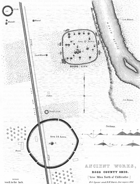
Squier and Davisís map of Mound City also shows a huge circle, just to the south. Its remnants lie in the fields along Route
104. Now much degraded, its ghostly remnants are still visible in old aerial photos.
When the highway was widened recently,
archaeologists investigated: The exterior ditch was originally twelve feet deep, and carefully lined with a foot-thick
layer of clay Ė to hold the slopes, and water. Associated burials in the central mound suggest this monumental work
was here before Mound City itself.
Itís probable that Shriver (circle) and Mound City (square) became prototypes for a new hybrid design at the Hopeton
Earthworks (just across the river), and in turn led to all the geometrical experimentation and perfection found in
the Paint Valley and at Newark and elsewhere throughout the Hopewell era.

Squier and Davisís drawing of Mound City and the huge Shriver Circle in 1848, also showing the canal and the future Route 104.


