TARLTON, THE GH ROAD
TARLTON CROSS
Leave downtown Circleville by SR 56, heading southeast, and in 9 miles go left on SR 159 for 4 miles into the village of Tarlton. Turn left immediately onto Reading Road for about ľ mile to a shaded parking area on the left.
In this Fairfield County Park, the Cross Mound is reached by a picturesque CCC-era concrete suspension bridge and pathway. The mound is shaped like a 90-foot plus-sign. A depression in its center may be original to the design, or an early modern intrusion. Archaeological explorations have not yielded any artifacts, or any definitive evidence of the date and cultural origins of the figure. The site is a narrow, slightly sloping ridge, and the Cross seems to have been shaped in a most unusual way: by the subtraction as well as the addition of soil. Dr. Brad Lepper explains:
It’s not simply a built up cross. The shape of the cross is partly determined by excavating the ground, the down slope part, and then taking that earth and piling it up to make the upslope part of the cross. So down slope when you do a soil profile, there is nothing; the mound isn’t constructed at all. The outer part of it was excavated away to define the cross. The upper part was built up.
Just to the southwest of the cross stand four earthen mounds, now obscured among the trees. The mounds have recently been discovered to form a perfect square, 260 feet on its diagonals – one quarter of the hypothetical “Hopewell Unit of Measure.”
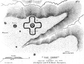
Squier and Davis illustrated the Cross Mound in 1848, showing some of the out-lying mounds later discovered to be in a perfect square.