TARLTON, THE GH ROAD
OHIO AND ERIE CANAL
Leave Chillicothe going north on State Route 104. About 12 miles above Mound City, turn right in the village of Westfall onto Canal Road, which parallels beautiful remnants of the old canal and towpath.
This route, and Canal Park outside Circleville, showcase some of the best remains of early Ohio’s ambitious canal system. This is a piece of the Ohio and Erie Canal, one of two systems created in the 1830’s to carry goods between the Great Lakes and the Ohio River. The canals were a huge undertaking, built largely by poor Irish laborers. The cost nearly bankrupted the state, but as the backers had hoped, they could carry products from Ohio’s farms, mills, and mines to eastern markets much more easily than wagons, and at one-fifth the cost.
Because both the canals and the ancient earthworks were built near Ohio’s rivers, they can often be found near each other. The Ohio and Erie, for example, is evident near Newark, and in Chillicothe. The canals gradually lost out to the railroads, and closed for good in 1913. In aptly-named towns like “Lockington” and “Lockbourne,” we can still see remnants of the canals: great stone hulks of elaborate locks, gates, and channels. But here, between Circleville and the village of Westfall, is a rare section with both waterway and tow-path intact.
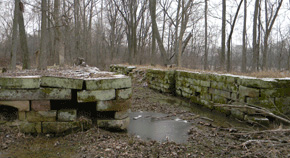
The remnants of massive stone canal locks are found along the former routes, often buried in the woods as here near Baltimore, Ohio.