NEWARK
THE GREAT HOPEWELL ROAD
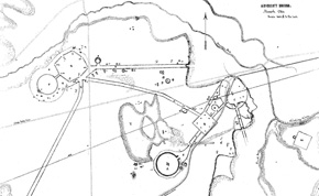
The southern gateway of the Octagon opens to a small stretch of grass and an exquisite small circular enclosure.
This is one of many that accompanied the Newark Earthworks as recorded on 19th century plans.
The remnants of low embankments just past the small circle the beginnings of a long straight roadway that took off to the
southwest. Early maps show it as consisting of perfectly straight parallel lines, about 180 feet apart and about 3 feet high,
extending for at least six miles. If it continued at this angle for sixty miles, as Dr. Bradley Lepper has suggested is
possible, this monumental highway (now termed the “Great Hopewell Road”) would have arrived at Chillicothe, where we
find more earthwork complexes with similar features, including the only other circle-octagon, High Bank Earthworks.
Southwest
of Newark, the lines that the early pioneers could trace through the forests and over the streams were plowed under or bulldozed
away long ago. Perhaps this was a road of pilgrimage, carrying great processions, between two of the greatest Hopewell
ritual centers.
Dr. Lepper had studied the long straight roads of the ancient American Southwest, before coming to Newark, so he was especially
intrigued when he found this remarkable feature on a never-published map of the Newark Earthworks, drawn by James
and Charles Salisbury in 1862:
They certainly did a very comprehensive survey of everything that was extant. They show the outer wall around the Octagon,
which nobody else but Wyrick showed. And also they pointed out that the parallel walls that came out of the
Octagon went much farther than Squier and Davis had said. Caleb Atwater thought those walls might go 30 miles.
The Salisburys say that they followed those walls two and a half miles and came to Ramp Creek. But they crossed Ramp
Creek, (and) said that the walls continued for six miles, through tangled swamps and over hills, still “keeping their
undeviating course.” So that’s where my work on the Great Hopewell Road really began.
The Salisbury Map was found by Dr. Lepper in the archives of the American Antiquarian Society in Worcester, Massachusetts.
Since Dr. Lepper’s discoveries in the 1990s, the “Great Hopewell Road” idea has captured the public imagination. But whether
it really existed, as we want to imagine it, can now probably never be confirmed:
It depends on how we define the “Great Hopewell Road.” If we define it as a pair of parallel walls that extended for
60 miles from Newark to Chillicothe, then it’s premature for the public or anyone else to accept that claim. If we define
the “Great Hopewell Road” as a corridor, a straight corridor connecting Newark and Chillicothe framed at least part of the way,
coming from Newark southwestward, by parallel walls, then I think the “Great Hopewell Road” for a certainty existed.
With such an ancient ceremonial roadway, Newark might have been one of the most important destinations in all of North America.
People brought exotic materials here from far away, like mica, obsidian, and copper. Maybe they were trading at a vast
Newark marketplace for the local Flint Ridge flint. Yet only tiny bits of Ohio flint have been found at the origin points
of those precious things. Dr. Lepper offers an explanation:
This was like Jerusalem or Santiago de Compostella. It was a place where people came from miles around, like Mecca.
It was a place of pilgrimage, and people were coming here bringing offerings, offerings of thanksgiving for a healing,
offerings in the hope of a blessing of some sort. And what they took back with them from their pilgrimage was that
spiritual power that was imparted to them at the site, and also perhaps a pilgrim’s token, a souvenir, some badge that says
“I’ve been on the Great Haj to Newark.”
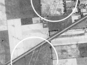
Aerial photos from the 1930s by Dasch Reeves show the walls of the “Great Hopewell Road” in fields southwest of Newark.