MARIETTA, MUSKINGUM
THE SACRA VIA
Old maps show the Sacra Via as a long, broad ramp with high earthen walls on both sides, leading up from the Muskingum River to Marietta’s large rectangular enclosure. Its monumental scale survives today as a park, a hundred and fifty feet wide. Such grand “graded ways” were often part of Ohio earthwork complexes.
The ramp was carefully engineered: its width crested in the center like a modern highway, its twenty-foot-high walls were lined with clay. This grand thoroughfare would have weathered floods well, and certainly would have impressed visitors arriving at the earthworks by boat. Its central axis is aligned with the winter solstice sunset; a mound probably marked the spot on the cliff top across the river.
Marietta’s first town council made a special resolution to preserve the Sacra Via, in their words, “as common ground…never to be disturbed or defaced.” But by 1882, when J.P. MacLean visited, the walls were gone. He wrote:
On inquiring what had become of these walls I was informed that the material had been moulded into bricks; that a brick-maker had been elected a member of the town council, and he had persuaded the other members to vote to sell him the walls.
The bricks ended up in a Unitarian Church, down the street. Yet even with only hints of its original walls, this ancient roadway is impressive, and the best preserved example of a Hopewell-era “graded way.”
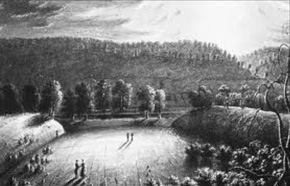
This early illustration of the Sacra Via by Charles Sullivan suggests the grandeur of the walls as they approach the river bank.