GREAT MIAMI VALLEY
CARLISLE FORT EARTHWORKS
Off of SR 4 about 2 miles south of Germantown, the Twin Rivers Metro Park covers bluff land overlooking Twin Creek. A trail from the south parking lot off Chamberlain Road leads to the Carlisle Fort Earthworks, a 3- to 4-foot high, roughly triangular enclosure built in the Hopewell era around a wooded hilltop.
The trail climbs toward an open meadow, then turns right along a well-preserved earthen wall that seems to glide through the woods atop steep, razor-back ridges. Carlisle Fort is little known today, partly because it was not included in Squier and Davis’s Ancient Monuments of the Mississippi Valley, though it was mapped in the 1830s by a physician named Samuel Binkley.
An especially impressive prow points to the southeast, down a long ridge. Dr. Jarrod Burks has compared Binkley’s early map with a modern topographic map, and has identified the remnants that are currently visible. Out in the open meadow, remote-sensing surveys have revealed the details of two circles, possibly gateways into the walled promontory.
Today the site is at risk of some severe erosion damage. Dr. Burks:
One unfortunate aspect of Carlisle Fort is, once you see those embankment walls, and you walk them, you notice that they seem to cut across deep ravines. Well, according to Binkley those ravines didn’t used to be there. It was much more continuous back in his day. So this is a site that really exemplifies the amount of erosion that has occurred, even since Europeans first started occupying the land. There are lots of gateways now, natural gateways, so to speak.
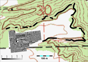
A composite of the USGS map of Carlisle Fort with modern field and remote sensing data (image by Dr. Jarrod Burks).