GREAT MIAMI VALLEY
MIAMI FORT
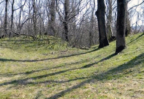
The hilltop enclosure called Miami Fort crowns a narrow precipice above the confluence of the Great Miami and Ohio rivers. From these walls the ancient people could look out over the rich marshes and waters below, and may have been able to see sister earthworks across both rivers. Trails follow the well-preserved walls and gateways, into prominent “prow” shapes, and deep ravines, and out to a majestic overlook.
Archaeologist Ken Tankersley is the most recent investigator here, and he has found fragments of earthen walls extending much farther than those recorded on nineteenth-century maps. He has also found evidence of habitations, water features, and great ceremonial posts:
We used ground-penetrating radar and proton magnetometry to go down the center of the earthworks, and we found very large posts, at a very consistent level, about every few meters.
Dr. Tankersley thinks they may have functioned like the one seen in American Indian villages, at the time of European contact:
American Indians are not really interested in time. But they are interested in location, they are interested in space. And one of the things that marks their space, areas that are important to them, both for their survival and spiritually, were marked on posts, with totems; totems are their kinship, their clan membership. And that’s what we see documented ethnohistorically, and that’s what we still see being used today among living Algonquian peoples.
This place remained important long after the original builders were gone: Dr. Tankersley has found that it was maintained, and added onto, right up until the time of European contact.
The standard map of Miami Fort has been that of Squier and Davis, from 1848. It shows the hilltop enclosure, and a couple of mounds. But there may be a lot more that never appeared on any 19th or even 20th century map. Architectural historian John Hancock:
Along the Little Turtle Trail in Shawnee Lookout Park, high on a bluff over the Ohio River, is a long piece of an earthen wall that no one in the 19th century apparently ever knew anything about. Ken Tankersley has discovered a whole system of these recently, that make the Miami Fort Complex apparently way bigger than anybody thought.
Earthen embankments have been detected along the ridges, and a pair of long lines paralleling the modern park road. Some of these never-before-recorded earthworks are but fragments, deep in the woods; others are more visible.
Walls of the southeastern prow of the earthwork, near the large level plateau, perhaps human-made, that occupies the eastern end of the main enclosure.
Archaeologist Tankersley talks about the water features he found at Miami Fort.
These earthworks were built on top of sand and gravel terraces, and on top of loess-capped hills: these are what we call “xeric environments,” and they are drought-prone. There’s also no natural water on these features. So if they’re living there, and also growing crops there, they had to have a source of water. And what we found at Shawnee Lookout, and Miami Fort, was a series of step dams, and ditches which carried runoff and channeled it into these dams, which were essentially built by the Hopewell, about 2,000 years ago, but then continued to be maintained all the way to historic contact.
Dr. Tankersley has also taken his investigations to Fort Ancient’s string of ponds, and to Newark’s Great Circle, where he has confirmed that the ditches and pools were purposely lined with limestone, and capped with clay, to retain water.
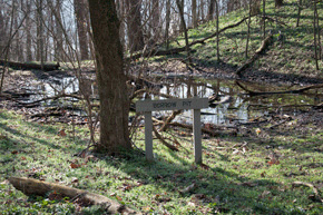
One of the most dramatic features at Miami Fort is a set of stepped ponds along the western enclosure wall, just before the path drops into a steep ravine.
The ancient earthwork at Miami Fort overlooks the site of Fort Finney, built (like Fort Harmar at Marietta) in 1775. Named after the military captain in command, the fort was to provide a place where Shawnee and Miami chiefs could meet and sign a treaty giving up all their land north of the Ohio to the new nation of the United States. The tribes farther east had already been pressured to give up their land, but the Shawnee and Miami here in the west had not.
Ohio Indian Commissioner Richard Butler set a time for a meeting, but most Shawnee and Miami leaders stayed away. Those who showed up at the fort were simply hungry, but when they discovered the agenda, they too rejected it. Here are Shawnee Chief Tame Hawk’s words:
As to the lands, it is all ours. You say you have goods for our women and children; you may keep your goods and give them to other nations, we will have none of them.
The Indians gave Butler a belt of black wampum, symbolizing disagreement. But Butler ground it under his heel, and otherwise convinced the Indians of his power. At last they gave in and signed. The commissioner got his treaty, but since the vast majority of Shawnee and Miami were not there, it turned out to be meaningless.

A digital terrain image of Miami Fort showing the prominent enclosure and the steep bluffs that surround it, above the Great Miami confluence (image by K. Tankersley).