FLINT RIDGE, COSHOCTON
BLACK HAND GORGE
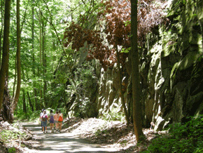
The Central Ohio Steam Railroad cut a deep crevice through the Black Hand Ridge, now the park’s “Blackhand Trail,” stained by soot from locomotives.
Leaving Newark on Route 16 east will take you past a newer architectural “wonder:” the bizarre, giant Longaberger Basket, probably one of the best-executed examples of literally iconic architecture in the US. Continuing on Route 16 for a total of 11 miles, exit at State Route 146, and then immediately right on Toboso Road for two miles to Blackhand Gorge Nature Preserve.
Here, the Licking River has cut a narrow gorge through a high sandstone ridge. This unusual chasm is named after a “black hand” petroglyph, left on the cliff face here long ago, that has inspired many Native legends: one proclaimed this was the boundary of long-sacred lands, where no man could raise his “hand” against another. The river here would have been a route for Flint Ridge flint, on its way down to the earthworks at Newark, and beyond.
In 1828, this section of the river became part of the Ohio and Erie Canal. The “Black Hand” was destroyed when the stone towpath was constructed along the riverbank. Besides the Central Ohio Steam Railroad, the electric inter-urban trolley car also came through a tunnel here on its way from Zanesville to Newark, Columbus, and Indianapolis.
A high trail skirts the large quarry where “Blackhand Sandstone” was taken for many of central Ohio’s monuments.
Leaving the Gorge, continue right on Toboso Road, then south on County Road 278 for 3 miles, then jog to the right for Ľ mile along Brushy Fork Creek. Take Mulberry Road to the left across the creek and continue southward 2 ˝ more miles before turning right onto Flint Ridge Road, which will bring you to Flint Ridge State Memorial.
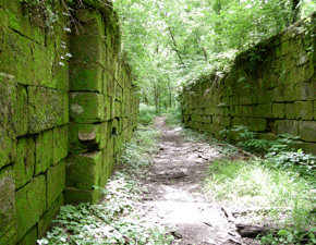
A trail at Black Hand Gorge (across the river from the parking lot) leads to a nearly-intact canal lock hidden in the woods.