FORT HILL,
PAINT VALLEY
VIEW FROM THE TOP OF SEIP MOUND
In this case it is not disrespectful to climb the mound and enjoy the view, since it is a complete reconstruction and the graves have all been removed. The view opens up to the whole valley including Baum Earthworks, Seip’s fellow-member of the “tripartite” tradition, the precipitous Alum Cliffs where ancients would have gathered this valuable substance, and the flat hilltop of Spruce Hill Fort.
Baum lies exactly where the valley seems to close up, four miles to the east. The Baum earthworks were across the river from the village of Bourneville, and traceable on aerial photos as late as the 1980s. Today they are invisible from ground level, and yet it is still possible to admire the Hopewell genius at marking out monumental geometric space within the bounds of these lovely hills, and to wonder at their placement of two such similar complexes literally within sight of each other along the river.
Atop the steep, prominent hill just east of the Baum site lies Spruce Hill Fort, a stone-walled hilltop enclosure even larger than Fort Ancient, and just recently acquired and placed under the management of the Hopewell Culture National Historical Park. Access is via a steep climb from its eastern flank, along Black Run Road, which may be arranged by contacting the Arc of Appalachia Preserve for a permit (937-365-1935), or checking in at the National Park’s headquarters at Mound City (or its web site) for the times and dates of periodic ranger-escorted tours.
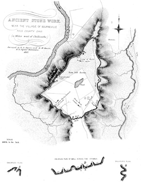
Spruce Hill Fort, Squier and Davis Drawing